NASA and the Indian Space Research Organisation (ISRO) have released the first radar maps from the joint NISAR mission, previewing how the satellite’s dual-band synthetic aperture radar will track changes on Earth’s land and ice surfaces ahead of the start of full science operations later this year.
Early radar maps highlight land-cover detail
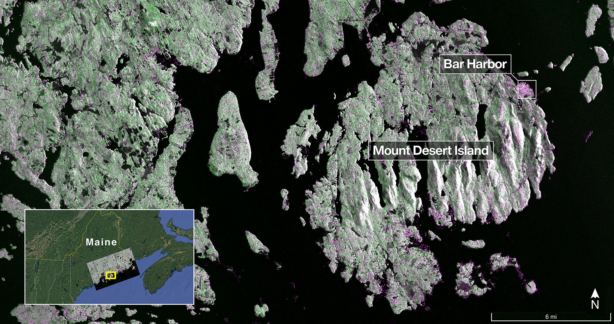
Using its NASA-provided L-band system, NISAR imaged Mount Desert Island, Maine, on Aug. 21, resolving features as small as about 5 meters. Dark tones reveal water, green highlights forested areas, and magenta corresponds to hard or regular surfaces such as bare ground and buildings, capturing narrow waterways and islets surrounding the island. On Aug. 23, an additional L-band observation covered parts of Grand Forks and Walsh counties in North Dakota, depicting wetlands and forests along the Forest River and surrounding agricultural plots. Dark fields appear fallow, while lighter areas indicate pasture or active crops, with circular patterns marking center-pivot irrigation.
Dual-band payload and global coverage
NISAR is the first spacecraft to fly both L-band (25-centimeter wavelength) and S-band (10-centimeter wavelength) radar. L-band signals penetrate vegetation and can measure soil moisture and subtle ground and ice motion down to fractions of an inch, supporting studies of earthquakes, volcanoes, landslides, and glacier dynamics. S-band is more sensitive to smaller vegetation, aiding monitoring of certain crops and grasslands. The mission operates from a 747-kilometer (464-mile) orbit, using a 12-meter drum-shaped reflector antenna, and is designed to observe Earth’s land and ice surfaces twice every 12 days.
What the data will enable
- Disaster response: Rapid mapping of surface deformation before and after earthquakes, volcanic activity, and landslides.
- Infrastructure monitoring: Detection of gradual ground subsidence and surface stability around critical assets.
- Agriculture and water: Tracking crop conditions, irrigation patterns, and soil moisture.
- Ecosystems: Assessing gains and losses in forests and wetlands, and characterizing biomass and land cover.
- Cryosphere: Measuring ice-sheet flow and seasonal freeze/thaw transitions.
Mission status and partnership
The spacecraft launched on July 30 and reached its operational orbit in mid-September. The science phase is expected to begin in November following ongoing instrument checkout and calibration. The NISAR mission reflects a long-running U.S.-India partnership: ISRO’s Space Applications Centre supplied the S-band SAR; the U R Rao Satellite Centre built the spacecraft bus; Vikram Sarabhai Space Centre provided the launch vehicle with launch services from Satish Dhawan Space Centre; and the ISRO Telemetry, Tracking and Command Network supports operations through its global ground stations. On the U.S. side, NASA’s Jet Propulsion Laboratory (managed by Caltech) leads the contribution, providing the L-band SAR, the antenna reflector and boom, the high-rate science data downlink system, a solid-state recorder, and the payload data subsystem. NASA’s Goddard Space Flight Center manages the Near Space Network, which receives NISAR’s L-band data.
These initial observations demonstrate how NISAR’s combined radar frequencies will generate consistent, high-resolution measurements to inform research and decision-making across hazards, resources, and climate-related applications.
Source: NASA news release