NASA’s latest Earth science update underscores steady progress across flagship missions that are reshaping global environmental monitoring. Highlights include commissioning milestones for NISAR, new data products and cadence gains for Landsat and the Harmonized Landsat–Sentinel-2 (HLS) suite, and a clear pathway to higher-resolution soil moisture mapping by pairing SMAP heritage with NISAR’s L-band radar.
NISAR commissioning reaches key deployment milestone
The joint NASA–ISRO NISAR mission launched on July 30, 2025, and has entered an approximately 90-day commissioning phase. The 12 m radar antenna reflector deployed on August 15, marking a critical step toward the start of science operations, which are anticipated around the beginning of November. Operating both L-band and S-band synthetic aperture radars, NISAR is designed to measure centimeter-scale changes across Earth’s surface with a 12-day repeat cycle. All science data are planned to be freely and openly available.
By comparing L-band and S-band returns, researchers will track ecosystem disturbance, natural hazards, and hydrologic change with improved consistency and global coverage. The deployment and ongoing radar tuning position the mission to deliver wide-area, time-series deformation and land cover dynamics at scale.
SMAP–NISAR pathway to 1 km weekly soil moisture
After more than a decade of L-band radiometry, SMAP products continue to set the benchmark for surface soil moisture, vegetation optical depth, and freeze/thaw state. These data have advanced drought and flood assessments and improved numerical weather prediction. Building on the SMAP Active–Passive algorithm originally fused with Sentinel-1 C-band SAR, NASA plans to adapt the approach to NISAR’s L-band, targeting global soil moisture estimates at approximately 1 km resolution on a weekly cadence.
The SMAP Early Adopter program has broadened operational uptake, including use of L-band vegetation optical depth to track water exchanges across the soil–vegetation–atmosphere continuum. Looking ahead, Europe’s Copernicus Imaging Microwave Radiometer (CIMR) mission, if launched, would extend multi-frequency microwave radiometry at L-band and other channels, following SMAP-like strategies for interference detection and latency.
Landsat milestones and HLS expansion
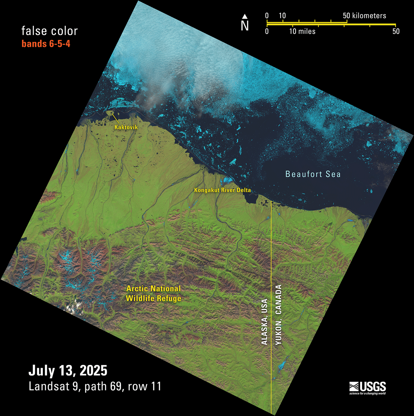
Landsat 9 collected its one-millionth image on July 13, 2025, while Landsat 7 was decommissioned on June 4, 2025, after more than 26 years in orbit and over 3.3 million images. Operating together, Landsat 8 and 9 maintain an eight-day global revisit for consistent land surface monitoring.
The Harmonized Landsat–Sentinel-2 (HLS) product integrates Landsat 8/9 with Sentinel-2A/B/C to deliver 1.6-day average revisit over land, enabling near-temporal continuity for change detection and agricultural monitoring. In February 2025, HLS added nine vegetation indices, with historical processing to 2013 scheduled to complete by early 2026 and low-latency HLS products planned for late 2026.
GEDI, OCO, and ABoVE updates
Reinstalled on the ISS in April 2024, the GEDI lidar continues to produce high-quality 3D structure observations, amassing 33 billion land surface returns by late November 2024. Version 2.1 products are available, and Version 3.0 is in preparation with improvements to geolocation, filtering, and algorithms.
OCO-2 has sustained a decade-long record of atmospheric CO2 from space, and OCO-3 has extended coverage from the ISS since 2019 with enhanced urban and tropical sampling. Together, they inform carbon cycle science, agricultural forecasting, and fire-risk models.
The Arctic–Boreal Vulnerability Experiment (ABoVE) enters its final year, transitioning from data collection to synthesis. Spanning three phases since 2015, ABoVE comprises 67 NASA-funded projects and over 1,000 researchers, integrating field, airborne, and satellite assets to quantify ecosystem change across Alaska and western Canada.
Why this matters for space and Earth data users
- NISAR’s dual-frequency SAR and 12-day repeat cycle enable global deformation, biomass, and hazard monitoring with uniform methods.
- SMAP–NISAR fusion targets approximately 1 km weekly soil moisture, unlocking higher-resolution hydrology for agriculture, insurance, and infrastructure risk.
- HLS’s 1.6-day revisit and new indices strengthen operational analytics for crops, forestry, and disaster response.
- GEDI’s waveform lidar and OCO’s CO2 time series expand 3D biomass and atmospheric carbon intelligence for climate services.
Together, these missions advance open, interoperable Earth observations that can be operationalized by commercial analytics providers, public agencies, and research institutions.
Source: NASA Earth Science Update