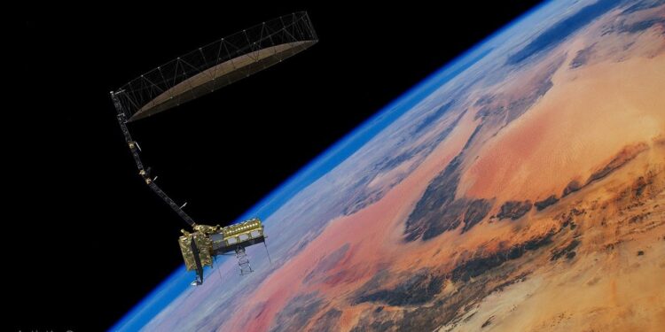
The NASA-ISRO Synthetic Aperture Radar mission, NISAR, has cleared on-orbit commissioning and is on track to begin science operations this fall. Following a July 30 launch, the Earth-observing satellite completed major post-launch activations, including deployment of its 12-meter radar antenna reflector and power-on of both the dual-band synthetic aperture radar instruments. The team initiated orbit raising on Aug. 26 to reach a mean altitude of 747 kilometers, with science-quality radar images expected in the coming weeks.
Mission status and timeline
- July 30: Launch.
- Aug. 15: 12-meter radar antenna reflector deployed.
- Mid-August: L-band and S-band SAR systems powered on.
- Aug. 26: Orbit raising toward 747-kilometer operational altitude began.
- Early fall: Initial science-quality radar imaging anticipated; full operations targeted about 90 days after launch.
What the instruments will measure
NISAR is the first mission to fly two SAR systems together. The L-band radar operates at a 24-centimeter wavelength, enabling penetration of forest canopies to assess soil moisture, forest biomass, and deformation of land and ice surfaces. The S-band radar, at 10 centimeters, is sensitive to smaller vegetation structures and certain types of agriculture, grassland ecosystems, and moisture in snow. Both bands collect data day and night, through clouds and precipitation.
Coverage and science targets
The satellite is designed to monitor most of Earth’s land and ice surfaces twice every 12 days. It will track change in forests, frozen regions, major infrastructure, and the planet’s crust at sub-centimeter scales. These measurements support studies of surface motion before, during, and after earthquakes, volcanic activity, and landslides, and provide consistent, repeatable observations for land, cryosphere, and ecosystem science.
International partnership and systems
NISAR is a joint mission spanning years of collaboration between NASA and the Indian Space Research Organisation. ISRO provided the S-band SAR and the spacecraft bus, coordinated launch services from Satish Dhawan Space Centre, and is executing early operations via the ISRO Telemetry, Tracking and Command Network ground stations. NASA’s Jet Propulsion Laboratory leads the U.S. contribution, supplying the L-band SAR, the deployable reflector and boom, the high-rate science data downlink, a solid-state recorder, and the payload data subsystem. NASA’s Goddard Space Flight Center manages the Near Space Network that receives NISAR’s L-band data.
Why it matters
Frequent, all-weather, day-night radar imaging will build a global baseline of Earth surface motion and land cover dynamics. Consistent time series from L- and S-band observations are expected to improve understanding of hydrology, biomass change, snow and ice processes, and crustal deformation, informing models of natural hazards and environmental change.
What’s next
The mission team will continue orbit-raising, instrument calibration, and data validation to deliver science-quality imagery. Full routine operations are planned for this fall, roughly 90 days after launch, enabling systematic global acquisitions on the nominal revisit schedule.
Source: NASA


