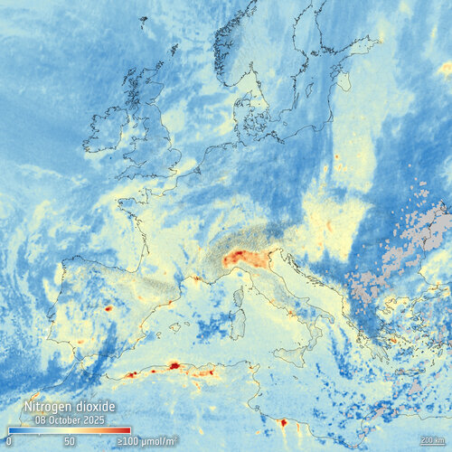
The Copernicus Sentinel-4 mission has produced its first-light images, marking a key step toward routine, hourly air-quality mapping over Europe and northern Africa from geostationary orbit. Hosted on the first Meteosat Third Generation Sounder satellite (MTG‑S1) and launched in July 2025, the ultraviolet–visible–near‑infrared spectrometer is in commissioning while calibration and data-processing chains are validated. From 36,000 km above Earth, Sentinel‑4 is designed to deliver near‑real‑time observations of key atmospheric pollutants to support monitoring and forecasting.
Key first-light findings
- Nitrogen dioxide (NO2): The first tropospheric map shows pronounced hotspots along the Mediterranean coast and over Italy’s Po Valley. Areas under cloud are absent due to measurement limitations in cloudy scenes.
- Sulphur dioxide (SO2): A distinct plume is detected from Mount Etna, drifting southeast over the sea. Beyond volcanic sources, SO2 also arises from maritime traffic using high-sulphur fuels and certain power generation activities.
- Ozone (O3): Vertical column values fall within expected ranges, with a broad maximum over the Balkans and Greece and a minimum over the Baltic region. The large‑scale pattern aligns with contemporaneous observations from heritage sensors such as GOME‑2 (MetOp) and Tropomi (Sentinel‑5P).
Why geostationary observations matter
Unlike polar-orbiting sensors that overpass once or twice per day, Sentinel‑4 maintains an uninterrupted view of the same region, enabling updates roughly every hour. This cadence captures rapid changes in urban and industrial emissions, shipping lanes, and episodic events such as volcanic releases or atmospheric transport episodes. The data are expected to complement low‑Earth‑orbit datasets by filling temporal gaps and improving the skill of short‑term air‑quality analyses and forecasts.
How Sentinel‑4 observes
Sentinel‑4 measures sunlight reflected by Earth’s surface and atmosphere, resolving spectral fingerprints of trace gases and aerosols. Once operational, it will routinely map:
- Nitrogen dioxide (NO2)
- Sulphur dioxide (SO2)
- Ozone (O3)
- Formaldehyde (HCHO)
- Glyoxal (CHOCHO)
- Aerosols
These products are planned for ingestion by the Copernicus Atmosphere Monitoring Service to support near‑real‑time applications across the region.
Status and next steps
The preliminary results, derived from measurements on 8 October 2025, indicate the instrument and ground segment are performing to expectations during commissioning. False‑color radiance imagery confirms the sensor’s spectral response over land, ocean, and cloud. As commissioning progresses, routine delivery of geostationary air‑composition data is anticipated in the coming months, expanding Europe’s operational capability for atmospheric monitoring.
Implications for the space and environmental sectors
Hourly geostationary air‑quality data can enhance urban pollution tracking, maritime emissions surveillance, and rapid assessment of volcanic plumes. For the space industry, Sentinel‑4 demonstrates an integrated meteorology–atmospheric composition architecture on MTG‑S1, underscoring the value of hosted payloads and combined mission designs for service continuity and responsiveness.
Source: ESA – Sentinel‑4 offers first glimpses of air pollutants